Saturday 3 December 2016

Nov 2016 speaker

Helen Page, Peachester History Committee
Guest speaker at BIHS meeting November 2016

Lynne Hooper (centre) with Jan (left) and Helen of
Peachester History Committee
Photo: Lynne Hooper
Through a fascinating PowerPoint presentation filled with photos and documents that had been given to the Peachester History Committee by Inigo Jones’ family, Helen gave us an incredible insight into the life and work of Inigo Jones.

Inigo Owen Jones (1872-1954), meteorologist, was born at Croydon, Surrey, England, son of Owen Jones, civil engineer, and his wife Emilie Susanne, née Bernoulli, of a famous scientific family. Emilie's mother Dorothy Inigo-Jones was descended from the architect Inigo Jones (1573-1652).

In 1874 his parents migrated to Queensland.  In 1888 the colonial meteorologist Clement Wragge persuaded Inigo to serve a cadetship in his office rather than attend the University of Sydney. Inigo began to develop a special interest in long-range forecasting on the basis of sunspots from that time.

In 1892 his parents bought a farm about 97 km north of Brisbane and named it Crohamhurst after a property near Inigo's birthplace. Inigo joined them there and on 2 February 1893 recorded an Australian record for one day's rainfall of 37.714 inches (958 mm). For the next thirty years he lived in relative obscurity, helping his father with pioneering work on the farm and continuing meteorological research as a hobby stimulated by first-hand experience of the farmer's dependence on weather forecasts.

In 1923 Inigo successfully predicted the end of a dry spell and the resulting press publicity created demands for his forecasts. Urged on by scientific and other friends, he became a full-time forecaster. From 1929 he wrote forecasts for many Australian newspapers.

The observatory building at Crohamhurst, was opened on 13 August 1935 and Inigo divided his time between work on the farm and work in the observatory. In 1942 Sydney grazing interests provided further support through the Long-Range Weather Forecasting Trust.


An accomplished artist and musician, Inigo married Marion Emma Comrie on 11 January 1905 at Crohamhurst.  

Peachester Cemetery
Photo: Lynne Hooper
Peachester Cemetery
Photo: Lynne Hooper

Inigo Jones died at Crohamhurst on 14 November 1954 and was buried in the nearby Peachester cemetery.


BIHS members visit to Peachester Hall
18 November 2016

BIHS group at Peachester Hall, 18 Nov 2016
Photo: Lynne Hoope
r
A group of BIHS members went on Friday, 18 November 2016 to Peachester and, after a cuppa and a talk, the Peachester Historical Committee took our group on a tour of the historical Peachester Cemetery.  

Helen and BIHS group at Peachester Hall, 18 Nov 2016
Photo: Lynne Hooper
BIHS group at Peachester Hall, 18 Nov 2016
Photo: Lynne Hooper


BIHS members visit to Bankfoot House
18 November 2016
Bankfoot House, 18 Nov 2016
Photo: Lynne Hooper
The group then drove to Bankfoot House, at the Glass House Mountains, where after a presentation by Ron Gillinder they explored Bankfoot House in the company of the Friends of Bankfoot House.

Ron's talk to BIHS group at Bankfoot House
Photo: Lynne Hooper
Ron's talk to BIHS group at Bankfoot House
Photo: Lynne Hooper


Monday 28 November 2016

Bribie Island WW2 Fortifications

Second World War Fortifications on Bribie Island

One of the most documented topics of Bribie Island history are the Second World War Fortifications located at several sites on the island.

The sites were entered into the Queensland Historical Register on 20 July 1993 (QHR 601143) and itemised as follows:

Fort Bribie No.1 Gun Emplacement (1939 - 1943)
Fort Bribie Southern Searchlight (1939 - 1943)
Fort Bribie No. 2 Gun Emplacement (1939 - 1943)
Fort Bribie Northerly Mine Control Hut (1939 - 1943)
Fort Bribie Southerly Mine Control Hut (1939 - 1943)
Fort Bribie Northern Searchlight (1939 - 1943)
Fort Bribie Battery Observation Post (1939 - 1943)
Fort Bribie Signals Operation Room (1939 - 1943)
Fort Bribie Pump House (1939 - 1943)
Fort Bribie Sewerage Treatment Works (1939 - 1943)
Skirmish Point Fortress Observation Post (1942 - 1943)
RAN Station No.4 Control Post (1942 - 1943)
RAN Station No.4 Southerly Engine Room (1942 - 1943)
RAN Station No.4 Northerly Engine Room (1942 - 1943)

Two of the criteria for the sites being added to the Queensland Heritage Register are: 

"They are important in exhibiting a range of aesthetic characteristics valued by the community, in particular the isolation, and sense of place, of the Fort Bribie fortifications, and the sense of discovery enhanced by the overgrown landscape; the form, scale and materials of the Fort Bribie, Skirmish Point Battery and Royal Australian Navy Station No.4 fortifications; and the siting and landmark quality of Fort Bribie, Skirmish Point Battery and the Royal Australian Navy Station No.4 fortifications." [QHR entry, Significance criterion E.]

"They have a strong association with the Second World War Queensland defence efforts of the Australian Military Force and Royal Australian Navy." [QHR entry, Significance criterion H.]

The full entry on the Queensland Historical Register covering significance, history, description and images can be viewed at https://environment.ehp.qld.gov.au/heritage-register/detail/?id=601143


Northern Searchlight - 1980.
Photo: Ronald Powell
Northern Searchlight - 2013.
Photo: QHR entry 601143


Fort Bribie Northern Searchlight (1939 - 1943)


Southern gun emplacement from east - 2013
Photo: QHR entry 601143
Southern gun emplacement from north - 2013
Photo: QHR entry 601143


Fort Bribie No.1 Gun Emplacement (1939 - 1943)


Southern Searchlight - 2013.
Photo: QHR entry 601143
Fort Bribie Southern Searchlight (1939 - 1943)

Northern Gun Emplacement - Dec 1953
Photo: BIHS DC_IW_001_gun
Fort Bribie No. 2 Gun Emplacement (1939 - 1943)

Further reading on the history of Fort Bribie during World War Two:

Dr Richard Walding's website has comprehensive information about 
Fort Bribie
RAN2 Controlled Mining Station and 
Royal Australian Navy Indicator Loop Station (Ran No.4)


Acknowledgements:
Queensland Heritage Register, Queensland Government, entry 601143

Tuesday 25 October 2016

Souvenir of Bribie postcards 1947

Souvenir of Bribie Island, 12 views
Postcard folder circa 1947


BIHS has recently recorded in our historical database, a folder of 12 postcards entitled Souvenir of Bribie Island.

The folder of black and white pictures was probably produced by Murray Views, Gympie around the year 1947. Some of the same scenes, with colour added, appeared in Camera Views of Bribie Island the following year.

Each postcard has a caption which describes the location of the picture as it was around 1947.  So not only can we see familiar island vistas as they were almost 70 years ago - we can also read what they were called at the time!


1. Pacific Paradise Guest House, Woorim, Bribie Island, Q.

2. Reflections, Third Lagoon, Bribie Island, Q.

 3. Pumicestone Passage, with Glasshouse Mountain in Background, Bribie Island, Q.

4. Ocean Beach Road, Bribie Island, Q. [Later First Avenue]

5. S.S. Koopa departing Bribie Island, Q.

6. At Bribie Island, Q. [Bribie Bowls Club]

7. Hotel Bribie, Bribie Island, Q.

8. Banya Street, Bribie Island, Q.

9. Bribie Foreshore, Bribie Island, Q. [Huts known as The 12 Apostles in background]

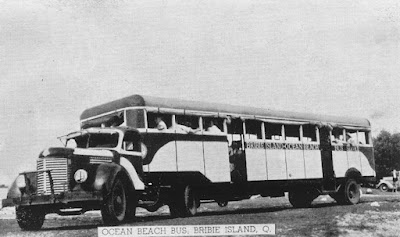
10. Ocean Beach Bus, Bribie Island, Q.

 11. Ocean Beach, Bribie Island, Q.

12. Glimpse of Bribie Island, Q. [Bongaree Jetty]

Acknowledgements
Murray Views, Gympie.

If you would like to share your Bribie Island postcards - our email address is bribiehistoricalsociety@gmail.com

Bribie postcards 1970s

Bribie Island
Postcard folder circa 1970

BIHS has recently recorded in our historical database, a folder of 6 postcards entitled simply Bribie Island Qld.

The folder was produced by Murray Views, Gympie around the year 1970.

Each postcard has a caption which describes the location of the picture as it was around 1970.  So not only can we see familiar island vistas as they were almost 45 years ago - we can also read what they were called at the time!


 Toll Bridge from Toorbul Point to Bribie Island 
[There were toll charges to cross the Bribie Bridge from 19 October 1963 to 22 March 1975.]


Bongaree Beach and jetty


Shopping Centre, Bribie Island [First Avenue, Bongaree]


Ocean Beach, Bribie Island


Picnic area, Bongaree Beach


Pumicestone Passage and bridge, Bribie Island

Acknowledgements
Murray Views, Gympie.


If you would like to share your Bribie Island postcards - our email address is bribiehistoricalsociety@gmail.com

Sunday 16 October 2016

Bribie Island in the sun 1980

Cross the Bridge to Bribie Island: Queensland's island in the sun
brochure circa 1980


BIHS has recently recorded in our historical database, a tourist brochure entitled Cross the Bridge to Bribie Island: Queensland's island in the sun.
The brochure was produced by the Bribie Island Chamber of Commerce in conjunction with Caboolture Shire Council and Queensland Tourist and Travel Corporation around the year 1980.
While some of the scenes depicted in the brochure could have been taken yesterday, other scenes are of attractions from days gone by.


Koolamara Motel 


These scenes are timeless!


Sun, sand and sea!

The Saddlers' Restaurant 


Our Bowls and Golf Clubs are still very popular!
A montage of the Glasshouse Mountains in the background
with the bridge and Pumicestone Passage in the foreground.

Sculpture of Ian Fairweather in a tree trunk
near a replica of his hut.

Acknowledgements
The above brochure was reproduced on this blog with the kind permission of the Bribie Island Chamber of Commerce.

Further reading:
Squatters Restaurant (BIHS Blogspot) with a copy of a 1989 article ... 
.... Squatters Homestead has been a landmark on Bribie for 14 years [in 1989].  It was built by Don Buckley...

If you would like to share your Bribie Island postcards - our email address is bribiehistoricalsociety@gmail.com